
Ancient sites archive
Allt Goch Sites
Allt Goch cairns, stones and hut site. Please click or touch pictures to enlarge the image.
Explore this area →Standing stones, cairns, stone circles and burial monuments in the Elan and Claerwen valleys.
Explore the sites ↓The Elan Valley has evidence of occupation and landscape clearance from the later Neolithic and early Bronze Age. Cairns, standing stones, alignments and stone circles remain on the hills and ridges. This archive records the monuments, photographs, OS grid references and site visits.
Browse the original photographic records and research.
Allt Goch cairns, stones and hut site. Please click or touch pictures to enlarge the image.
Explore this area →
Ancient sites of the Elan Valley north of the Old Aber Mountain Road.
Explore this area →Ancient sites of the Elan Valley west of the Elan Valley Reservoirs and north of Claerwen Reservoirs.
Explore this area →Ancient sites of the Elan Valley east of the Penygarreg and Craig Goch Reservoirs.
Explore this area →Ancient sites of the Elan Valley south of Caban Coch, Dolymynach and Claerwen Reservoirs.
Explore this area →
Ancient and archaeological sites outside the Elan Valley Estate.
Explore this area →
Banc Ty Coch cairns and possible cairns. Please click or touch pictures to enlarge the image.
Explore this area →
Blaen Y Clawdd Du Cairns are north west of Bodtalog Farm. Map Ref: SN880 764
Explore this area →
Bwlch Y Ddau Faen lies between Drygarn Fawr and Gorllwyn, south of Claerwen Dam. Map Ref: SN894 583
Explore this area →
Carn Garnfallt is south east of Elan Village. Map Ref: SN940 645
Explore this area →
Cairns on Cefn Bach and Esgair y Llwyn, on the hill opposite Aber Glanhirin Farm. Map Ref: SN905 735
Explore this area →
The area to the west of Garreg Ddu Reservoir. Map Ref: SN896 651
Explore this area →
The area to the south of Caban Coch Dam. This Bronze Age settlement has remains of cairns and stones. Map Ref: SN926 635
Explore this area →
Craig Ddu is south east of Elan Village. Map Ref: SN957 622
Explore this area →Craig Ddu is south east of Elan Village. Map Ref: SN957 622
Explore this area →
The large expanse of land to the west of Craig Goch Reservoir. Map Ref: SN870 700
Explore this area →
Craig Llysiau lies south east of Rhiwnant Farm. Map Ref: SN885 611
Explore this area →
The area to the south of Caban Coch Dam. This Bronze Age settlement has remains of a stone circle, huts, cairns and many stones. Map Ref: SN932 628
Explore this area →
Cwm Pistyll on Llanwrthwl Common. Main Map Ref: SN94206 60495. Please click or touch pictures to enlarge the image.
Explore this area →
Drygarn Fawr is one of the highest summits in Mid Wales, standing at 645 metres or 2114 feet above sea level. The summit is topped by two distinctive, large beehive-type
Explore this area →
Esgair Ganol lies south of Claerwen Dam and is a difficult area to get to. Map Ref: SN870 605
Explore this area →
Area to the south west of Dol y Manach Dam. Map Ref: SN915 615
Explore this area →
Esgair Hafod Area lies south of Rhiwnant Farm. Map Ref: SN890 604
Explore this area →
The area to the east of Craig Goch Dam. Map Ref: SN920 690
Explore this area →
The area to the east of Craig Goch Reservoir. Map Ref: SN920 690
Explore this area →
The area to the south of Caban Coch Dam. The site has remains of some very large cairns. Map Ref: SN946 612
Explore this area →
Historic sites, field notes, grid references and photographs.
Explore this area →
The area to the south east of Caban Coch Reservoir. There are plenty of cairns, some are very well preserved with central cists. Gro Hill is a short walk from Crugiau Bac
Explore this area →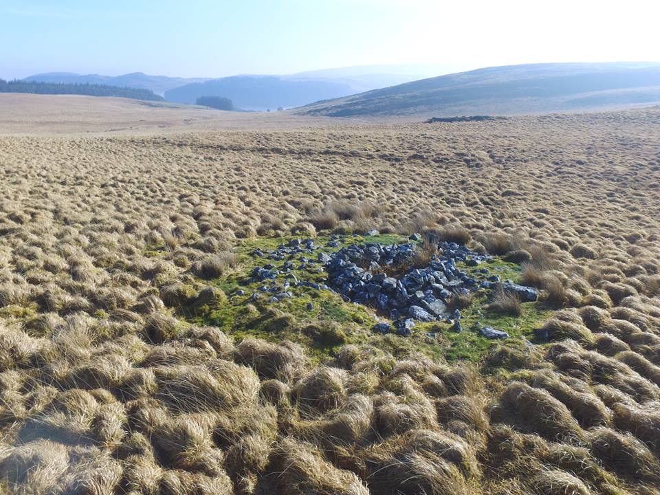
Historic sites, field notes, grid references and photographs.
Explore this area →
Lan Fraith Round Barrow, a Bronze Age burial site near Glan Hirin. Map Ref: SN8744 7224
Explore this area →
Maen Hir Cairns, Maen Hir Stone and Cistfaen Cairns. Map Ref: SN860 760
Explore this area →
Nant Y Dderwen Area lies south of Claerwen Dam. Map Ref: SN871 630
Explore this area →
The area to the north of Claerwen Reservoir, near Nantybeddau Farm. Map Ref: SN8470 650
Explore this area →Ancient sites outside the Elan Valley Estate.
Explore this area →
A remote area to the south of Caban Coch Reservoir. Map Ref: SN916 588
Explore this area →
Penrhiw-Wen is just off the old Aberystwyth Mountain Road and includes two standing stones — Maen Serth / Esgair Dderw Standing Stone and Maengwyngweddw Stone (The White
Explore this area →
Rhos y Gelynnen Sites are above Nantgwyllt Church and consist of stone rows, cairns, a mound and standing stones. Map Ref: SN904 630
Explore this area →
Tyn y Llidiart Cairn Map Ref: SN9086 6580
Explore this area →
The area to the north and north west of the Teifi Pools. Map Ref: SN790 690
Explore this area →
The area to the west of Teifi Pools. Map Ref: SN800 630
Explore this area →
The area to the east of Garreg Ddu Reservoir. Map Ref: SN925 655
Explore this area →The historic site areas are shown on the original map. It gives an overview of the districts covered by the survey.
Enlarge the area mapAncientSites/Map/PublicMap.php, remains accessible from the Map page.Mapped sites are based on recorded Ordnance Survey grid references. Select a marker for more details.
Zoom and drag to explore. Ordnance Survey Leisure mapping is used when a site-restricted OS key has been configured; otherwise OpenStreetMap is displayed.